Guided Tour - Maritime Atlases - Exhibition

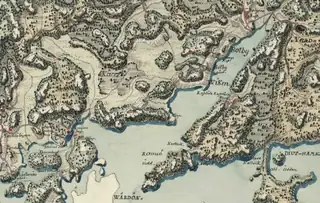
A guided tour through the exhibition "Maritime Atlases - Maps' Journey in the Baltic Sea". The exhibition presents the fundamentals of marine cartography and traces the history of Baltic Sea mapping during the 17th-19th centuries, focusing on four major atlases. The maps offer Swedish, Dutch, Russian, and English perspectives on the entire Baltic Sea region.
The first true maritime charts of the Baltic Sea were created in the late 16th century, and over the following centuries, Swedes and Russians established the foundation for systematic marine cartography. Maritime charts were cutting-edge technology of their time - strategically and economically valuable documents that were carefully protected.
The maps on display are part of the John Nurminen Foundation's maritime collection, which comprises nearly a thousand historical maps dating from the 15th century onward. The collection's core consists of eight rare atlases, some of whose images are featured in the exhibition.
Ehrensvärd Museum, Helsinki. Guided tour 27.8.2026, 16.00-16.45. Admission 4-7 €.
Lectures · Helsinki 514 in the next 30 days →
 52lectureMon 9.11.Kanneltalo's Author Guests, Autumn 2026
 49lectureTue 6.10.Sara Lundberg in conversation with Philip Teir
 49lectureWed 7.10.Jarkko Martikainen at Jakomäki Library as Part of the "About Love" Series
 45lectureTue 6.10.Vuotalo Author Guests, Autumn 2026
 45lectureTue 20.10.Vuotalo Tuesday Matinee Lectures
 43lectureTue 6.10.The Baltic Sea 1916-1945: The Battle for Högland and Other True Stories from the Wars
 99concertSun 18.10.Placebo
 95festivalThu 8.10.Timo Lassy - When the Saxophone Returns
 95festivalFri 16.10.Pagan Weekend 2026
 95concertMon 22.2.Five Finger Death Punch | Premium Suite Ticket
 94concertThu 19.11.Iiro Rantala - An Evening with Iiro
 86stand-upSun 8.11.Nicko McBrain - An Evening With Nicko McBrain